Audio Transcription
 Datasets and Services for Training LLM
 Image Annotation
 Video Annotation
 Text Annotation
 Lidar Annotation
 Crowdsourcing
 MedTech Companies
 Banking and Finance Industry
 Biometric Data
 E-commerce and Retail
 Surveys and UX-Researches
 Agriculture
 Retail
 Robotics
 Augmented Reality
 Finance
 E-Commerce
 Face Recognition System
 Ore Annotation
 Content Moderation on the Video
 IBeta 2
 Data Collection for Face and Speech Recognition
 Content Moderation
 Video Systems and Video Analysis
 Content Moderation in Recruitment Domain
 Audio Labeling for Call Center
 Data collection and video annotation: weapon detection on the streets
 Image Annotation for Emotion Recognition
 Data Сollection for Сity Administration
 Liveness Detection
 Annotation Photos for the Recognition System
 Blog
Blog Stages of Work
 Become a Partner
 Student Program
 FAQ
FAQ3D POINT CLOUD ANNOTATION SERVICES


What is 3D Point Cloud Annotation?
Computer Vision

Object Detection and Classification
Semantic Segmentation

Instance Segmentation

3D Object Localization and Pose Estimation

Ground Truth Generation for LiDAR Data

Anomaly Detection and Anomaly Annotation

Environmental Mapping and Spatial Analysis

Building Information Modeling (BIM) Integration
Infrastructure Asset Management

Augmented Reality Content Creation
How we Deliver 3D Point Cloud Annotation Projects
At TrainingData, we are dedicated to delivering 3D Point Cloud Annotation Projects with precision, efficiency, and client satisfaction as our top priorities. Our process comprises several key stages, each meticulously designed to ensure accuracy, quality, and timely delivery.
3D Point Cloud Annotation Use Cases
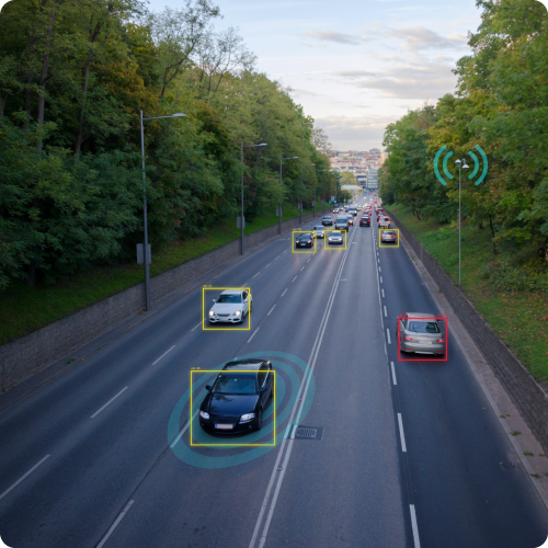
Autonomous Driving and Vehicle Perception
Automotive companies use 3D point cloud annotation data to train perception algorithms for autonomous vehicles. Annotations enable detecting and classifying objects such as vehicles, pedestrians, and road signs, enhancing the vehicle's ability to navigate safely and make informed decisions in complex traffic scenarios.
Robotics and Industrial Automation
Robotics companies leverage annotation data to enable robots to perceive and interact with their environment. Annotations aid in object recognition, grasping, and manipulation tasks, allowing robots to operate autonomously in industrial settings such as warehouses, factories, and manufacturing facilities.
Augmented Reality and Virtual Reality Content Creation
Entertainment and gaming companies order annotation services to create immersive AR and VR experiences. Annotations enable accurate object placement, scene reconstruction, and interaction in virtual environments, enhancing the realism and interactivity of gaming, simulations, and virtual tours.
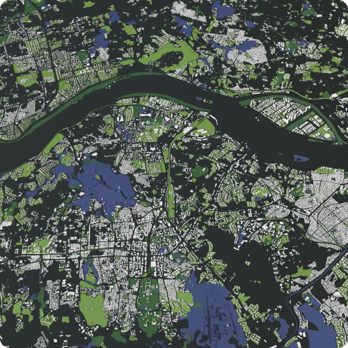
Urban Planning and Smart Cities
Urban planning agencies use annotated data to analyze urban environments and plan infrastructure projects. Annotations facilitate identifying buildings, streets, parks, and other urban features, supporting city modeling, zoning regulations, and sustainable development initiatives for smart cities.
Architectural and Construction Visualization
Architecture and construction firms employ 3D point cloud annotation data to visualize building designs and construction progress. Annotations aid in creating digital twins, as-built models, and renovation plans based on accurate spatial data, improving project coordination, and decision-making throughout the building lifecycle.
Environmental Monitoring and Natural Resource Management
Environmental agencies leverage 3D point cloud annotation data to monitor ecosystems and manage natural resources. Annotations enable mapping terrain features, vegetation cover, and land use changes, supporting habitat conservation, watershed management, and environmental impact assessments.
Geological Exploration and Mining
Mining companies use annotation services to explore geological formations and plan mining operations. Annotations aid in identifying ore bodies, estimating reserves, and assessing geological hazards, improving the efficiency and safety of mineral extraction processes.
Agriculture and Precision Farming
Agricultural companies utilize annotated data to monitor crop health and optimize farming practices. Annotations enable measuring plant height, canopy density, and soil moisture content, supporting precision agriculture techniques such as variable rate application of fertilizers and pesticides.
Historical Preservation and Cultural Heritage Conservation
Cultural heritage organizations employ data annotation to document and preserve historical sites and artifacts. Annotations aid in creating detailed 3D reconstructions of monuments, archaeological sites, and cultural artifacts, facilitating virtual conservation efforts and heritage preservation initiatives.
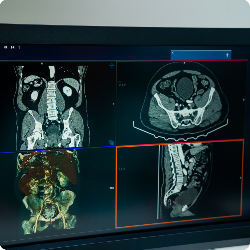
Medical Imaging and Healthcare Simulation
Healthcare institutions utilize 3D point cloud annotation data to visualize medical imaging scans and simulate surgical procedures. Annotations enable segmenting anatomical structures, identifying pathological features, and planning personalized treatment strategies, enhancing medical diagnosis and patient care
Stages of work
-
Application
/01Leave a request on the website for a free consultation with an expert. Th e acco unt manager will guide you on the services, timelines, and price -
Free pilot
/02We will conduct a test pilot project for you and provide a golden set, based on which we will determine the final technical requirements and approve project metrics -
Agreement
/03We prepare a contract and all necessary documentation upon the request of your accountants and lawyers -
Workflow customization
/04We form a pool of suitable tools and assign an experienced manager who will be in touch with you regarding all project details -
Quality control
/05Data uploads for verification are done iteratively, allowing your team to review and approve collected/annotated data -
Post-payment
/06You pay for the work after receiving the data in agreed quality and quantity
Timeline
-
24 hoursApplication
-
24 hoursConsultation
-
1 to 3 daysPilot
-
1 to 5 daysConducting a pilot
-
1 day to several yearsCarrying out work on the project
-
1 to 5 daysQuality control
in the established quality and quantity
Why
Training Data
- Quality Assurance:
-
Enhanced Data Accuracy
-
Consistency in Labels
-
Reliable Ground Truth
-
Mitigation of Annotation Biases
-
Cost and Time Efficiency
- Data Security and Confidentiality:
-
GDPR Compliance
-
Non-disclosure agreement
-
Data Encryption
-
Multiple data storage options
-
Access Controls and Authentication
- Expert Team:
-
6 years in industry
-
35 top project managers
-
40+ languages
-
100+ countries
-
250k+ assessors
- Flexible and Scalable Solutions:
-
24/7 availability of customer service
-
100% post payment
-
$550 minimum check
-
Variable Workload
-
Customized Solutions