Audio Transcription
 Datasets and Services for Training LLM
 Image Annotation
 Video Annotation
 Text Annotation
 Lidar Annotation
 Crowdsourcing
 MedTech Companies
 Banking and Finance Industry
 Biometric Data
 E-commerce and Retail
 Surveys and UX-Researches
 Agriculture
 Retail
 Robotics
 Augmented Reality
 Finance
 E-Commerce
 Face Recognition System
 Ore Annotation
 Content Moderation on the Video
 IBeta 2
 Data Collection for Face and Speech Recognition
 Content Moderation
 Video Systems and Video Analysis
 Content Moderation in Recruitment Domain
 Audio Labeling for Call Center
 Data collection and video annotation: weapon detection on the streets
 Image Annotation for Emotion Recognition
 Data Сollection for Сity Administration
 Liveness Detection
 Annotation Photos for the Recognition System
 Blog
Blog Stages of Work
 Become a Partner
 Student Program
 FAQ
FAQGEOSPATIAL ANNOTATION SERVICES
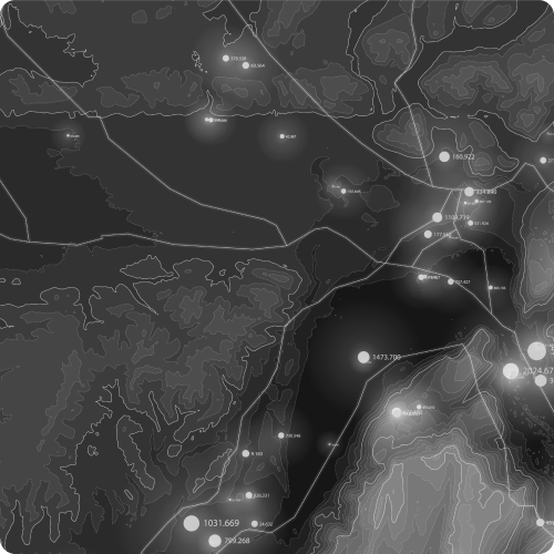
What is Geospatial Annotation?
Types of Geospatial Annotation Services

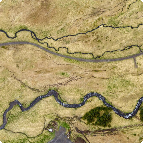
Land Cover Classification

Object Detection and Segmentation

Point of Interest (POI) Annotation

Route and Path Annotation
Geospatial Attribute Tagging
Landmark Recognition and Localization

Change Detection and Monitoring

Boundary and Parcel Annotation

Remote Sensing Image Annotation

Street View Annotation
How we Deliver Geospatial Annotation Projects
At Training Data, we are committed to delivering Geospatial Annotation Projects with precision, efficiency, and client satisfaction as our top priorities. Our process encompasses several key stages, each meticulously designed to ensure accuracy, quality, and timely delivery.
Geospatial Annotation Use Cases
Urban Planning and Development
Urban planning agencies use geospatial annotation data to map land use, transportation networks, and infrastructure facilities. Annotations aid in identifying suitable locations for development projects, assessing environmental impacts, and optimizing urban growth strategies.
Precision Agriculture
Agriculture companies leverage geospatial annotation data to monitor crop health, soil moisture levels, and pest infestations. Annotations enable precision farming techniques, such as variable rate application of fertilizers and pesticides, leading to improved crop yields and resource efficiency.
Disaster Response and Emergency Management
Emergency response organizations utilize geospatial annotation data to map disaster-affected areas, assess damage severity, and plan rescue operations. Annotations aid in identifying evacuation routes, locating emergency shelters, and coordinating relief efforts during natural disasters or humanitarian crises.
Environmental Conservation and Management
Environmental agencies rely on geospatial annotation data to monitor wildlife habitats, biodiversity hotspots, and protected areas. Annotations facilitate habitat mapping, species tracking, and ecosystem monitoring, supporting conservation efforts and sustainable resource management.
Infrastructure Maintenance and Asset Management
Utility companies use geospatial annotation data to inventory infrastructure assets, such as power lines, pipelines, and telecommunications networks. Annotations aid in asset tracking, condition assessment, and maintenance planning, ensuring reliable service delivery and infrastructure resilience.
Real Estate and Property Management
Real estate firms leverage geospatial annotation data to assess property values, analyze market trends, and identify investment opportunities. Annotations enable visualizing property boundaries, zoning regulations, and neighborhood amenities, supporting property valuation and site selection processes.
Natural Resource Exploration and Mining
Mining companies utilize geospatial annotation data to identify mineral deposits, plan extraction operations, and assess environmental impacts. Annotations aid in geological mapping, resource estimation, and mine site rehabilitation, ensuring responsible resource extraction and land reclamation.
Transportation and Logistics
Transportation companies rely on geospatial annotation data to optimize route planning, track vehicle movements, and monitor supply chain operations. Annotations enable real-time vehicle tracking, congestion management, and delivery route optimization, enhancing efficiency and customer satisfaction.
Tourism and Recreation
Tourism agencies use geospatial annotation data to create interactive maps, highlight tourist attractions, and plan recreational activities. Annotations aid in showcasing scenic viewpoints, hiking trails, and cultural landmarks, attracting visitors and enhancing tourism experiences.
Telecommunications and Network Planning
Telecommunications providers utilize geospatial annotation data to plan network coverage, optimize cell tower placements, and assess signal strength. Annotations enable predicting network performance, identifying coverage gaps, and deploying infrastructure upgrades to improve connectivity and service quality.
Stages of work
-
Application
/01Leave a request on the website for a free consultation with an expert. Th e acco unt manager will guide you on the services, timelines, and price -
Free pilot
/02We will conduct a test pilot project for you and provide a golden set, based on which we will determine the final technical requirements and approve project metrics -
Agreement
/03We prepare a contract and all necessary documentation upon the request of your accountants and lawyers -
Workflow customization
/04We form a pool of suitable tools and assign an experienced manager who will be in touch with you regarding all project details -
Quality control
/05Data uploads for verification are done iteratively, allowing your team to review and approve collected/annotated data -
Post-payment
/06You pay for the work after receiving the data in agreed quality and quantity
Timeline
-
24 hoursApplication
-
24 hoursConsultation
-
1 to 3 daysPilot
-
1 to 5 daysConducting a pilot
-
1 day to several yearsCarrying out work on the project
-
1 to 5 daysQuality control
in the established quality and quantity
Why
Training Data
- Quality Assurance:
-
Enhanced Data Accuracy
-
Consistency in Labels
-
Reliable Ground Truth
-
Mitigation of Annotation Biases
-
Cost and Time Efficiency
- Data Security and Confidentiality:
-
GDPR Compliance
-
Non-disclosure agreement
-
Data Encryption
-
Multiple data storage options
-
Access Controls and Authentication
- Expert Team:
-
6 years in industry
-
35 top project managers
-
40+ languages
-
100+ countries
-
250k+ assessors
- Flexible and Scalable Solutions:
-
24/7 availability of customer service
-
100% post payment
-
$550 minimum check
-
Variable Workload
-
Customized Solutions