Audio Transcription
 Datasets and Services for Training LLM
 Image Annotation
 Video Annotation
 Text Annotation
 Lidar Annotation
 Crowdsourcing
 MedTech Companies
 Banking and Finance Industry
 Biometric Data
 E-commerce and Retail
 Surveys and UX-Researches
 Agriculture
 Retail
 Robotics
 Augmented Reality
 Finance
 E-Commerce
 Face Recognition System
 Ore Annotation
 Content Moderation on the Video
 IBeta 2
 Data Collection for Face and Speech Recognition
 Content Moderation
 Video Systems and Video Analysis
 Content Moderation in Recruitment Domain
 Audio Labeling for Call Center
 Data collection and video annotation: weapon detection on the streets
 Image Annotation for Emotion Recognition
 Data Сollection for Сity Administration
 Liveness Detection
 Annotation Photos for the Recognition System
 Blog
Blog Stages of Work
 Become a Partner
 Student Program
 FAQ
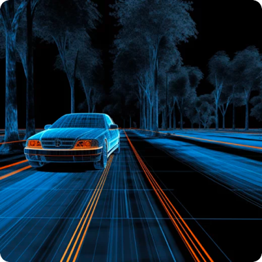
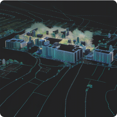
FAQLIDAR ANNOTATION
Training Data provides a full cycle of work on marking lidar clouds to create high-quality training datasets

Lidar
(Light Detection and Ranging)
It uses a laser beam to measure distances to surrounding objects and create a point cloud representing a 3D map of the scene. Labeling LiDAR point clouds involves identifying and classifying objects using data obtained from the LiDAR sensor.
Services
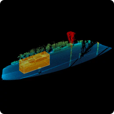
Point Cloud
A point cloud is a set of three-dimensional coordinate points that describe the geometry and location of objects in a scene
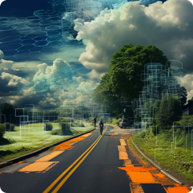
3D Object Recognition
Processing of point clouds, three-dimensional models and voxel grids obtained from lidars, stereo cameras or structured light scanners
Terrain modeling
Analysis and processing of data such as altitude maps, laser scans, aerial images to describe the shape and characteristics of the earth's surface and objects
Path Planning and Navigation
Determining the best way to reach the destination, including analysis and consideration of factors: obstacles, road conditions, travel time and user preferences
Change Detection
Detection and classification of changes: deforestation, expansion of buildings, soil erosion, changes in water bodies and other important changes for environmental assessment and management
Virtual Reality and Simulation
Tasks such as gesture recognition, object classification in virtual space, behavioral modeling to develop adaptive responses to user actions
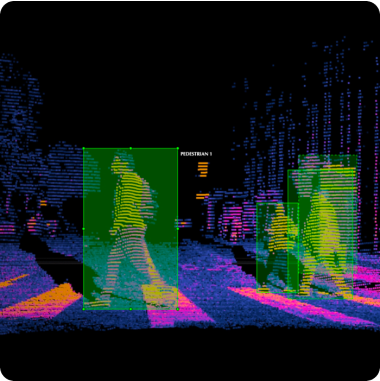
Object Detection
Identification and classification of objects of various types, such as cars, pedestrians, cyclists, buildings, road markings, signs, trees, etc.
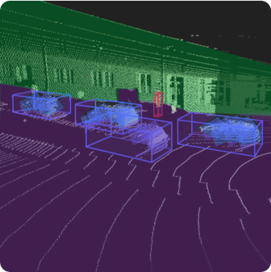
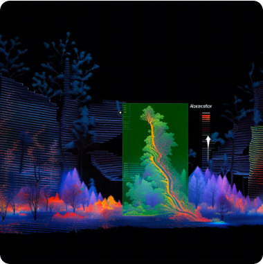
Semantic Segmentation
Dividing lidar clouds into small components and determining which classes these components belong to for a deeper understanding of AI systems of the environment
Stages of work
-
Application
/01Leave a request on the website for a free consultation with an expert. Th e acco unt manager will guide you on the services, timelines, and price -
Free pilot
/02We will conduct a test pilot project for you and provide a golden set, based on which we will determine the final technical requirements and approve project metrics -
Agreement
/03We prepare a contract and all necessary documentation upon the request of your accountants and lawyers -
Workflow customization
/04We form a pool of suitable tools and assign an experienced manager who will be in touch with you regarding all project details -
Quality control
/05Data uploads for verification are done iteratively, allowing your team to review and approve collected/annotated data -
Post-payment
/06You pay for the work after receiving the data in agreed quality and quantity
Timeline
-
24 hoursApplication
-
24 hoursConsultation
-
1 to 3 daysPilot
-
1 to 5 daysConducting a pilot
-
1 day to several yearsCarrying out work on the project
-
1 to 5 daysQuality control
You pay for the work after you have received the data
in the established quality and quantity
in the established quality and quantity
Why
Training Data
- Quality Assurance:
-
Enhanced Data Accuracy
-
Consistency in Labels
-
Reliable Ground Truth
-
Mitigation of Annotation Biases
-
Cost and Time Efficiency
- Data Security and Confidentiality:
-
GDPR Compliance
-
Non-disclosure agreement
-
Data Encryption
-
Multiple data storage options
-
Access Controls and Authentication
- Expert Team:
-
6 years in industry
-
35 top project managers
-
40+ languages
-
100+ countries
-
250k+ assessors
- Flexible and Scalable Solutions:
-
24/7 availability of customer service
-
100% post payment
-
$550 minimum check
-
Variable Workload
-
Customized Solutions